
09/04/2025
From Champoluc we drove just a few kms back down the road to the town of Brusson, a tourism centre further down the Ayas valley. The sosta here is just before the town, in the hamlet of Vollon, next to the river and the Ski de Fond (Nordic Ski) Centre.
Brusson Sosta
The write ups on S4S and P4N for this sosta gave us contradictory reviews of it’s status. Was it closed for winter or open all year round? We felt it was worth checking out. In the winter the Ski de Fond track passes through the sosta which we imagined might make it difficult to park. But we were pretty convinced that there would be no snow now so fingers crossed we would have somewhere to park.
Our sat nav directed us into the sosta via a side entrance but we soon realised there was a barrier system in place across the main entrance to the car park. It was all a bit mysterious, some large rocks had obviously been moved away from the side entrance we had used. Presumably they were usually used to block it off.
We wandered over to the barriers but they didn’t appear to be working. We drove round to them in case they were triggered by a sensor, but nothing. So we parked back up and connected to a EHU point. With a niggling guilty conscience we walked down to the Ski de Fond bar which was listed as a place to find further information, but it was closed. We could have gone further and phoned the support number, but we procrastinated over that one. If someone wanted payment from us they would turn up and ask for it. Until then we were happy to take advantage of a freebie.

Parking at Brusson
A little while later a German van turned up and went through the same motions. After they had gone back and forth a few times they came over to find out what we were doing. They decided to take the same approach. Later a police car drove into the car park, but just used it as a turning point.
We tried to work out where the Nordic ski track would normally run. There is a bridge over the road which seems to be part of the track and then we think that the track runs through the central grassy area of the car park to access the fields behind. If that’s the case then at least half of the car park should be accessible even in the depths of winter.
Around Lake Brusson
The reason the Ski de Fond bar was closed was probably related to the fact that there was no snow on the nordic ski trails. Apart from some snow and ice on the paths under the shade of the trees there was no snow to be seen. We popped out for a wander down the river and around the nearby lake. It was t-shirt weather with blue skies and no breeze to cool us down. Pussy willows along the river were adorned with their fluffy catkins and the earliest spring flowers were almost over.

Signs of spring – fuzzy catkins
We didn’t venture far into Brusson. Many houses and apartments were shut up and it seemed very quiet. The gentlemen I had spoken to in Champoluc had a holiday home here and they had told me that the majority of the houses were holiday homes. Many Italian families have a second home in the mountains to escape from the stifling heat of the city in summer.
On the way back we scouted out the shops of Vollon. The mini market was shut but we found the excellent Agrifoglio, a local producer’s alimentari with cheese, meats and a bakery. We bought ourselves several cured meats (the Speck was particularly delicious), sliced as thin as tissue paper, and discovered a new Italian word; an “etto” which is 100g. Very useful for ordering deli items.
A Walk to the Col de Joux
We prepared ourselves with a walk up to the Col de Joux by popping to the alimentari for panini to which we added meats and cheeses and some salad. We might have picked up some cakes too!
Our walk was going to take us to the Col de Joux, the point where the road from Chatillon crosses over into the Ayas valley. Google maps had kept trying to send us over this col on our way to Champoluc a few days previously and we were interested to see whether we had made the right choice by avoiding it. The local tourist office info said that the road was kept open all year and our conclusion was that we would only avoid it immediately after or during heavy snow.
The path up to the Col de Joux was an old mule track, presumably the original route over the col. On the way we found a carefully reconstructed stone water fountain. It was part of the old aqueduct – the Ru Courtod – that was an important source of water for the arid sides of the valley. A walk leads from here through the tunnels of the old aqueduct which we will definitely do in future. We didn’t know about it until after our walk.

Watering hole on the way up to the Col de Joux
The Col de Joux didnt give us the views we were expecting, but we got our vistas when we continued on our traverse above Brusson. The forest around us occasionally opened up and gave us stupendous views down into the valley and the mountains beyond. From here we could see Brusson’s ski slopes, now closed, and the village of Salomon nestled in a meadow on the opposite side of the valley, as well as looking down to our motorhome in it’s distant parking spot.
-

- Views
-

- Looking down to the valley – you can see the parking near the bottom of the picture
We even saw our first squirrel of the season scampering along the path in front of us. We’ve seen signs on some of our walk, pine cones stripped of their kernels and spread out along the paths, but this was our first sighting.
The path took us down to the village of Extrepieraz and then alongside the river back to our parking area.
-

- Extrepieraz
-
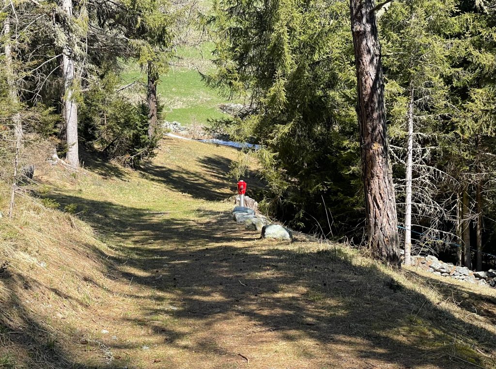
- There were plenty of these hydrants along the route
The riverside walk alone was worth the outing, it shares the route with the Ski de Fond, now snow-less but the occasional snow maker gave away the trail. From here we could see that our earlier path had been above sheer limestone cliffs and the metallic glints of equipment on the rocks showed us that this was a playground for climbers.
-

- Riverside
-

- Snow under the trees
-

- Climbers paradise
-

- Snow making facilities on the trail
Isollaz Waterfall
We left Brusson after our walk, deciding that we would certainly come back here in future to do more walking and maybe to try out the skiing. On the way back down the valley I wanted to stop to see a waterfall I’d seen signposted on the way up. The Cascate di Isollaz is accessed by a short but steep path from a parking spot that had just about enough room for our van to park ‘normally’. Despite thinking we’d be alone there were a couple of families here too. We descended the path past old mine buildings to find a waterfall that was definitely worth a visit even though Paul keeps comparing any waterfall we see with Iceland and they keep coming up short.
-
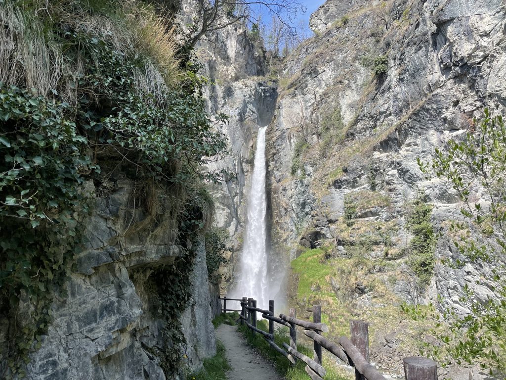
- Approaching the waterfall – the path isnt made for lots of visitors
-

- Ruined mine buildings
-
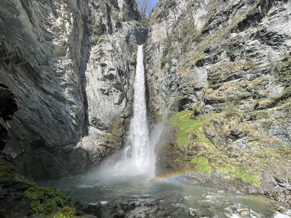
- The final view